Walking the San Luca Portico From City to Hill
A long line of arches runs out of Bologna toward a hilltop sanctuary. Its level stretch, bridge and ascent reveal how a roof can give a journey a recognizable form.
In this story 4 sections
Think of a street that remains recognizable after you turn a corner. The material of the pavement may continue, or a row of trees may guide the eye around the bend. On the way to the sanctuary of San Luca, the element that supplies this continuity is overhead. A long succession of arches and vaults starts in Bologna, crosses a road and accompanies a substantial climb. The roof gives the walk a recognizable form. Under it, the ground changes from city pavement to an uphill route with stairs. Outside it, the view and the kind of neighbourhood change at their own pace.
The City of Bologna describes a route of about 3.6 kilometres. Works on the level portion began in 1674, and building continued into the following century. The route served processions associated with the movement of the sacred image of the Madonna of San Luca down to the city. Today a visitor can study that connection on foot or in a set of pictures taken along the way. In either case, a sequence is more revealing than a view up the most handsome stretch of arches. Each stretch solves a particular problem of getting from one place to another.
The route beside Via Saragozza
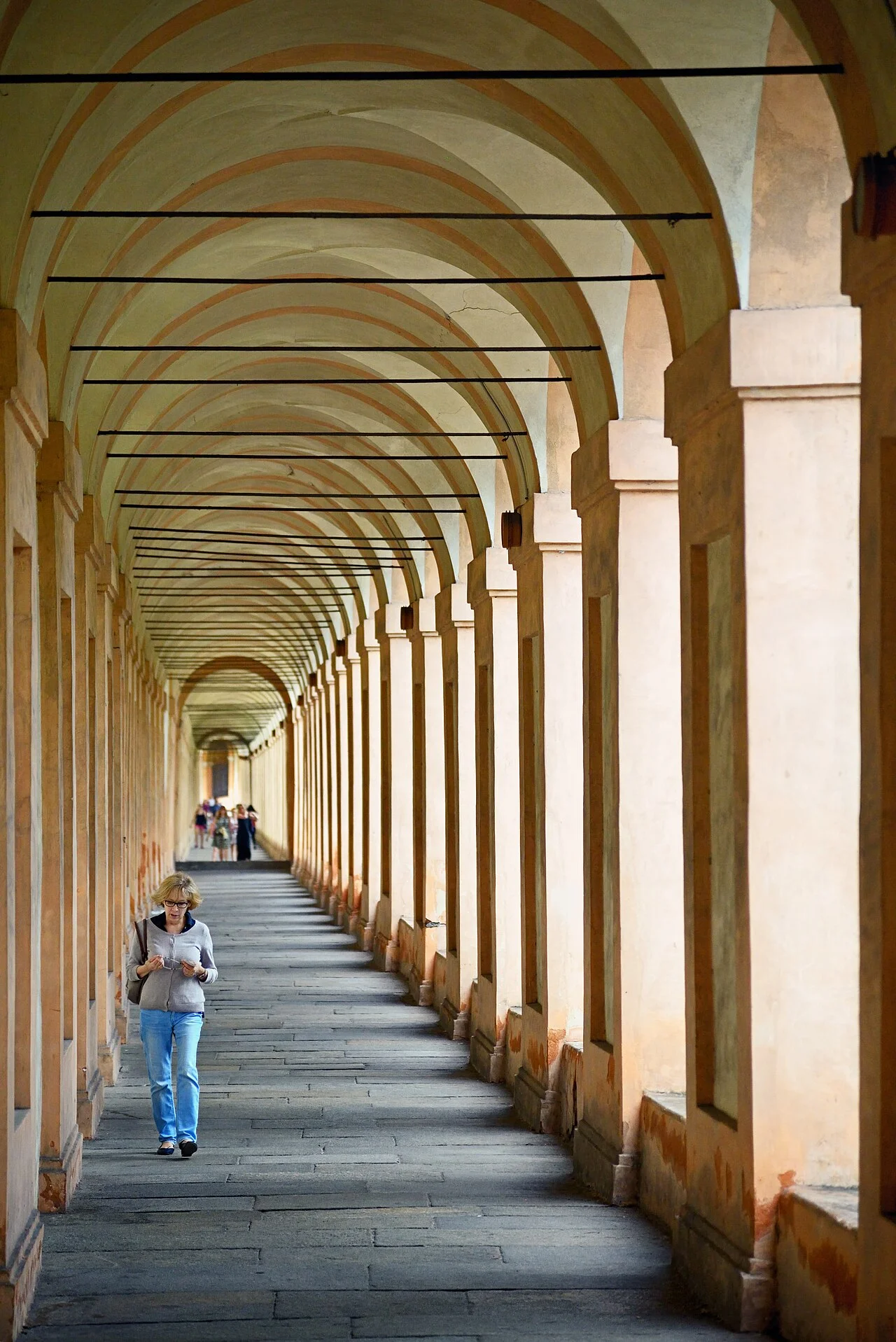
The first part follows Via Saragozza for about a kilometre and a half from the Arco Bonaccorsi. Watch how an arcade receives people on a level urban route. From inside it, read the street through the openings. A view along the pavement is more continuous than a view across the street because the supports regularly come between the eye and the opposite side. A person walking in the same direction as the arcade experiences a corridor. A person coming from the street experiences a series of places to enter. The same row of masonry organizes both movements.
Look down the inside edge of the line and then look at a single opening from across the road. The inside view emphasizes depth. Corresponding edges in adjacent openings appear closer together faster than you might expect, giving the eye a sense of distance even if the route ahead is briefly blocked. Across the road, one opening can behave as an address. An edge or a change in the building behind it gives the walker a way to identify where something happens. The human scale of a portico comes partly from that ability to shift between finding one place and moving through a whole series of them.
Think about a day when one side of a familiar street is more comfortable to walk along than the other. Shade can make a stretch usable longer in the afternoon. A roof can make a path more attractive during a shower, especially for someone who needs to keep one hand free or move at a slower pace. However, conditions at the openings still matter. A crosswind can send rain into the edge. Morning and afternoon light can change which places are exposed. Different parts of the route can serve these everyday roles alongside the much more specific uses associated with its origins.
The photograph of the long vault shows another way the open side makes itself felt. A light patch breaks between one pair of supports and then repeats between the next pair. The strip of wall on the other side carries few comparable openings. Someone wandering along under the vault sees a sequence of surfaces alternately facing the light and shielded from it. Individual bays can announce themselves without a sign. A visitor could recall a turn by the way the light entered it, or find a particular opening again after following a few similar ones. If you are comparing photographs, look for the direction in which the floor is lit. It can be a clearer sign of the open side than the distant end where edges seem to merge.
The place where the street crosses the route
At the Arco del Meloncello, the route and the road have to be reconciled. The municipal account describes the structure as an overhead crossing. To understand the choice, follow the path of one person approaching along the low section and the path of another person going down the road. A plain intersection would put their lines on the same piece of ground. A bridge makes two levels available while allowing the covered way to carry across. For somebody walking, the important consequence is a change in position and view at the same place where the larger street comes through.
Approach this point in a picture from each direction. From down the street, the crossing can look like a prominent architectural event in its own right. From the covered route it comes at a change in the structure of a longer walk. It is more legible if the viewer knows what each end connects to. A view of the façade alone can make the bridge look like a gateway whose next step is simply to pass through. A plan and an image from along the route can explain why this particular threshold had to work at more than one level.
The crossing is also a reminder that a roof can shape a section of city without taking ownership of all the movement nearby. Public routes meet other routes, some older and some altered since the original building. Different users see the crossing as a choice of direction, a place under which to pass or an opportunity to continue uphill under cover. The two lines have different speeds and purposes. Their meeting tells you something about the connection between hill and city that a view of the sanctuary on its own could never supply.
On the long ascent
Beyond the crossing the pavement climbs, with stairs on parts of the way. The repeated arch continues while distances begin to feel different in the body. A person may have an easy time guessing how many openings remain visible and a much less accurate guess about how long it will take to reach the last one. Steps, slopes and where someone might want to pause become part of the experience. They matter even if the rhythm of the vaults in a still photograph makes the distance look remarkably even.
The change can be understood without assuming that every opening is identical. Find two consecutive supports and imagine placing a level line across the scene, as in a rough survey drawing. The base of the near support and the base of the far one can sit at different heights. The repeating architectural feature needs to relate to those local positions. Pictures taken downhill compress the variation, while a photograph from one side may show the way rises and landings interrupt it. Use more than one angle before deciding which bit of the change belongs to the slope and which bit is an effect of perspective.
Approaching the sanctuary gives the route one last job. It has to carry a person from a moving line under cover into a place of arrival. The end may feel broader, more open, or more directed toward an entrance depending on which view you use. A visitor who has passed through a long string of similar-sized openings can feel that change even before reading a sign. The architecture supplies successive preparations for arrival: a change in ground, a shift in the view and a different arrangement of the edges close to the entrance.
Count for the question you are asking
The commonly repeated count of 666 arches deserves care. Bologna’s own account notes that the total varies with the counting method and reports a somewhat lower number under its reckoning. A viewer trying to settle the number should first decide whether an arch belongs to the count at crossings, additions and changes in the construction. A person trying to see the route as a succession of places has an easier goal. Two walkers can agree about where the climb starts, or about the effect of looking through an opening on a bend, without needing the same count for the entire line. A conventional number can be part of the history of how people remember the route.
The stretch to San Luca is one part of the larger UNESCO property. The inscription concerns several groups of Bologna’s porticoes, with a range of urban and architectural settings. Compare the uphill path with a section serving a line of small destinations in the city. It can be easier to see what they have in common once their work is clear. Both shelter people and divide the open side into recognizable intervals. One makes a journey between distant points feel like a single route. Another keeps a series of close destinations in reach of the same pavement.
If you keep a record of the walk, choose pictures before, during and after the climb. Put a simple note beside each giving the direction of the view, the relation of the route to the street and the kind of ground underfoot. The group will carry more information about the journey than a dozen views chosen only for the beauty of a vault. What persists between the views is the shelter. What changes is everything the shelter has been asked to join.