Read the Key Before the Street on a Sanborn Map
A fire insurance atlas can help recover a vanished building. Its index, sheet numbers and correction slips also show how easily an old map can be assigned the wrong address or date.
In this story 4 sections
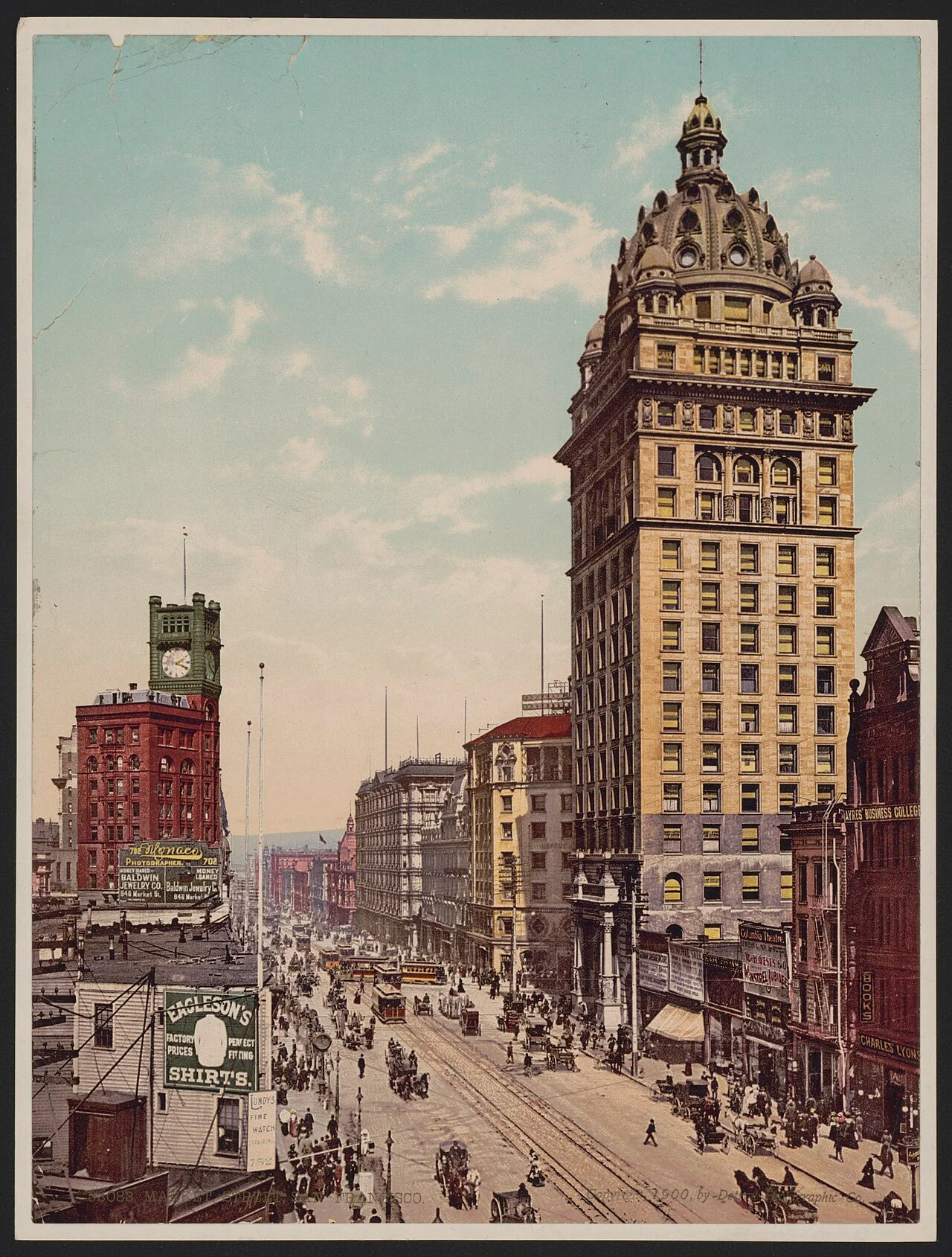
A historic photograph can bring hundreds of people onto a familiar street and reveal almost nothing about the construction of the building behind them. A fire insurance map can indicate construction material on a building that appears as a tiny coloured rectangle. The photograph of San Francisco’s Market Street accompanying this article belongs to the first kind of record. To use it alongside a Sanborn atlas, start by establishing what you want to recover: a position on the street, the footprint of a building, or a use that might have changed by the date of the atlas. Each has a different trail through the record.
The Sanborn Fire Insurance Map Company gathered detailed information about towns and cities for insurance purposes. Building materials, elevations, openings, industrial uses and the supply of water could matter to the people who read the maps. The material is also valuable to a reader tracing a shop, a family address or a vanished block. The difficulty is that a map designed for a specific business question has its own vocabulary and scope. The Library of Congress guide begins with the key, title and index because the street image itself cannot answer all the questions a contemporary reader brings to it.
Decide which location you already know
Suppose a letter gives you an address on a long street and the name of a cross street is missing. Your first useful document may be a street index. It can break the street into ranges or give several possible sheets. A name found in a modern search can lead to a perfectly real present-day place while sending you to the wrong part of a historical atlas. Old numbers and names may not agree with the ones on today’s sign. If a reliable contemporary record supplies two nearby intersections, those often provide a stronger way to identify an area than a solitary building number.
The graphic index, sometimes called a key map, works the other way. You can begin with a stretch of city or the shape of a street network and see which numbered sheet covers it. This becomes particularly useful for an atlas divided into volumes. Check both the volume’s relation to the city and the sheet’s relation to the volume. A file viewer may put the title or index toward the end of the set of images even when the paper atlas originally put it near the beginning. If an image index uses numbers of its own, keep the scan position separate from the number printed by the mapmaker.
Address and district information can also come from different dates. An address occupied by a business at the time of a city directory might sit on a lot occupied by another tenant at the time a particular plan was updated. A reasonably complete note gives both sources their own dates. A good match in street numbers does not itself establish that both records describe the same occupant. Once the block is located, the surrounding entries, crossings and boundaries can help clarify how close the match really is. You can then ask a question about the building without first having to settle who was inside it.
Read the numbers as instructions
A close view reveals how economical a map can be. Symbols and abbreviations record features that would take up much more space if written out. In the Library of Congress guide, red or pink marks construction such as brick or tile in the example key, while yellow indicates a frame building. A separate short mark can record the number of storeys or the presence of a basement. A porch, a wing or an addition can have a different description from the main part of the structure. When tracing one building, look for the boundary around each label before copying the colour and the text.
The key used with the edition is the best place to check those readings. A mark in a familiar colour may have its function explained by a line beside it. A scan can also make a pale colour hard to separate from a stain or a later addition. Compare the questionable area with a clearly labelled example on the same sheet or in the same key. If you cannot distinguish the lines, record the uncertainty in your note. That care can save a later researcher from assuming they are seeing a feature you never recovered with confidence.
Suppose a block contains a large rectangular building with a small rectangle attached along its street side. An account of the street could describe those as one structure from lived experience. The atlas may mark the two parts separately because the smaller part has a different height, a different purpose or a different construction. Read the join at high magnification, then return to the whole block. Edges visible in the atlas can make a later photograph newly intelligible. An extension that looked like a separate shop in the photograph may occupy a clearly attached piece of the plan.
Keep the dates of the changes
A sheet might contain a correction pasted onto its surface. The atlas was a working reference. Its individual sheets could continue to earn their keep after the rest of the volume was printed. Updates could be made by changing a part of the page or adding to a list. To a person browsing a clean digital copy, an amended atlas can look like one consistent record of one moment. A boundary around a correction or a date in the update material can place part of the information at a later point in the life of the atlas.
If you are comparing buildings before and after a change, note the full date given in the catalogue and any applicable date on the sheets. Then record which part of the block you are relying on. A statement such as “the edition was issued in one year and revised later” describes the source without yet proving when a particular structure was added or removed. A visible correction can narrow the relevant period. A second dated record of the building is usually a better way to pin down the event. The question “when did this appear on the plan?” can have a perfectly good answer even when the exact construction date remains uncertain.
The same caution applies to blank areas. The key map may show that some parts of town were outside this work’s coverage. Street names and properties considered relevant to insurance could receive detailed treatment in one district and relatively sparse treatment elsewhere. Absence from the visible part of one sheet could have several explanations. Before treating it as evidence that a place was gone, check the edges of the sheet, neighbouring pages and the purpose of the particular atlas. Coverage comes first. Claims about what an area contained follow from coverage and detail together.
Return to Market Street with two different questions
In the historical image from Market Street, the width of the road, the heights of some buildings and the view along the street become easy to take in. It is much harder to see how a building stretches back toward the next street or what stands immediately behind it. A map can make those relationships easy to discuss while giving little account of the mass of the façade. If you can identify a building confidently in two sources, keep both descriptions. Decide which visible feature helps anchor the relationship between them: a corner, an unusual turn of the street, a known building crossing several addresses, or the spacing between two intersections.
The cover is a photochrom print dated 1900. Its colour is part of the way the street was presented to viewers. On a Sanborn sheet, colour is part of the key. A red building in the street view does not gain a particular construction label by resembling a red patch on the atlas. Use the street sign, the shape of the block and the relative position of an identifiable building to bring the views into agreement. Then read colour according to the purpose of each record. The same ordinary word can refer to the appearance of a city in one description and to a category used by the surveyor in the other.
Next see whether the map confirms something you had only inferred from the photograph. A deep footprint may explain why an apparently small frontage was attached to substantial space. Several separately marked addresses may make a broad, continuous façade less straightforward to interpret. Conversely, a photograph can show an approach or a difference of height that an outline on paper makes difficult to imagine. The photographs and the atlas offer different forms of access to the same kind of place. The intersection is most valuable when you can specify which piece of information travels from one to the other.
Leave the next reader a short trail: city and edition, volume or sheet, nearest cross street, and the words or colours from the attached legend that support your reading. Add the source and date of any photograph used to establish orientation. That record makes it possible to revisit the block without guessing which of many similar sheets you meant. More of the old city survives in searchable form because the atlas once had to make a complicated place readable to a particular reader. A few careful notes can keep that precision available for a new question.